
Author: Computational Spatial Planning Laboratory, DTAP, UGM
Understanding urban spatial structures is fundamental for guiding equitable and sustainable urban development, particularly in cities undergoing rapid transformation in the Global South. Conventional approaches often depend on fixed administrative boundaries or outdated planning models, which inadequately reflect the fluid and evolving nature of urban spatial dynamics. These traditional frameworks tend to overlook the complex interactions and functional linkages that shape urban form and activity patterns, thereby limiting the effectiveness of urban planning and policy interventions. To address this gap, our study introduces an integrated geospatial methodology that combines diverse spatial datasets and advanced analytical techniques to delineate urban centers and sub-centers more accurately. By applying this approach to Magelang city and region in Central Java, Indonesia, the research highlights how combining multiple scales of spatial data—such as land use, transportation networks, and socio-economic indicators—can reveal nuanced spatial structures that traditional methods miss. This multi-scale analysis not only enhances the understanding of urban spatial functions but also provides a robust framework for planners and policymakers to identify emergent urban patterns and support more adaptive, context-sensitive urban development strategies.
In urban planning context, spatial structure can be conceptualized through Assemblage Theory as a dynamic and emergent configuration of interconnected urban amenities and services—encompassing the built environment, social practices, infrastructure, and flows of people and information. Rather than viewing cities as fixed entities, this perspective foregrounds the processes through which urban components coalesce, dissolve, and reconfigure over time, revealing the city as a living system that adapts to shifting needs and conditions. Drawing on the work of Deleuze and Guattari, urban space is perceived not as a static backdrop but as a fluid assemblage formed through continuous interaction between material and immaterial components (Deleuze, G., & Guattari, F. L, 1987). This perspective challenges traditional planning models that often regard urban form as a stable blueprint, instead emphasizing how urban spatial structures are continually reassembled through everyday practices, flows of movement, and socio-economic forces (Kamalipour & Peimani, 2015).
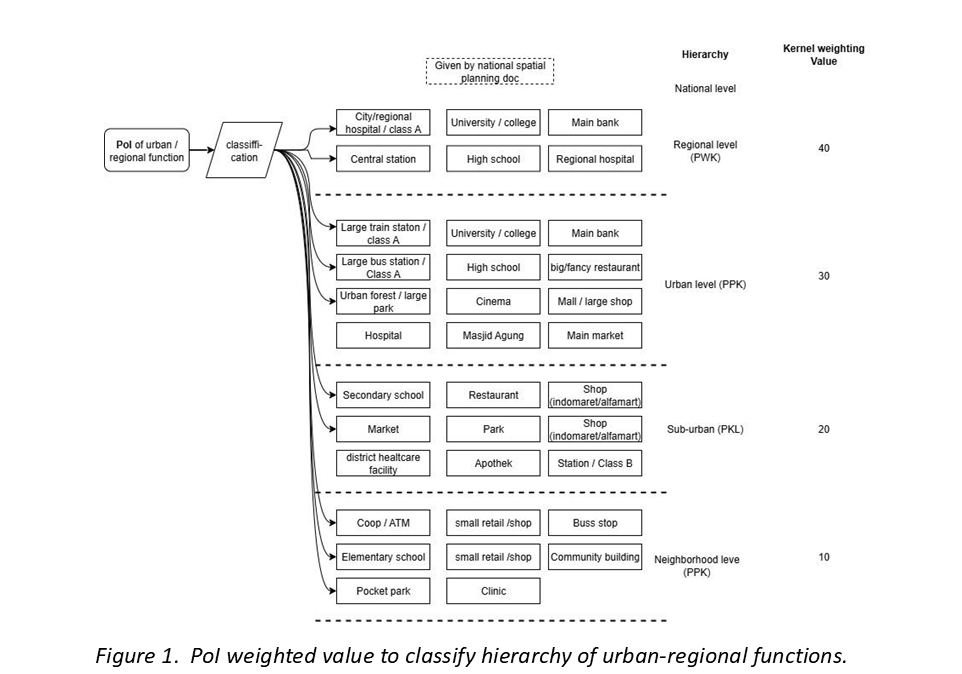
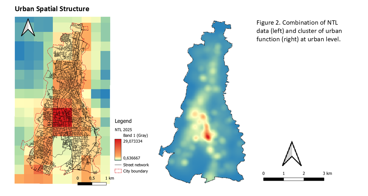
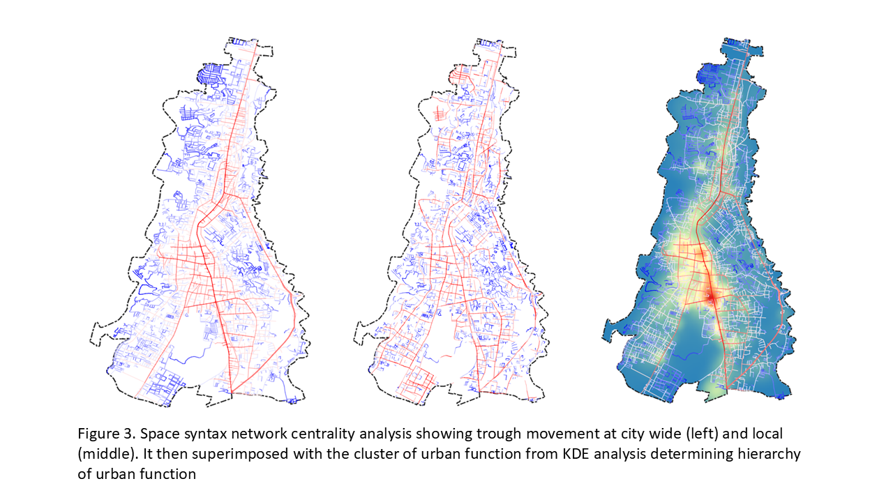
The aim of this research is to explore methodology for understanding spatial structure constituting data such as Kernel-PoI, NTL, and road network centrality. Identifying spatial structures through Kernel-PoI, NTL, and centrality can potentially address the scalability of activities across three different spatial scales, thereby offering a more contextual and precise understanding of spatial structures. The integration of these methods is anticipated to be replicated, developed, and implemented in spatial planning practices in Indonesia. This study integrated three complementary spatial methodologies to identify and validate urban spatial structures. Initially, Kernel Density Estimation (KDE) was applied to data concerning the distribution of infrastructure and amenities (PoI), encompassing commercial, educational, health, and recreational facilities, to capture the spatial concentration of urban functions and their zones of influence (Ren et al., 2023). Subsequently, Nighttime Light (NTL) data derived from satellite imagery were utilized to observe the intensity and distribution of nighttime activities, thereby providing insights into urban vitality and socio-economic dynamics beyond daytime hours. Finally, road network centrality analysis, grounded in network theory measures such as closeness centrality and betweenness centrality, was employed to explore the structural importance and accessibility hierarchy of road segments, reflecting the city’s fundamental movement framework (Rui & Ban, 2014; Fang et al., 2021). The author posits the methodological novelty lies in adopting the integrated spatial analysis to accurately portray multi-scale and constellations of urban-regional spatial structure in Indonesian context. By employing integrated spatial analysis planners can monitor patterns of intensity, connectivity, and transformation that reflect the evolving assembly of urban life. This approach advocates for a more adaptive and relational understanding of cities—one that is responsive to complexity, heterogeneity, and change (Chen et al., 2017).
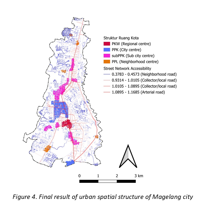
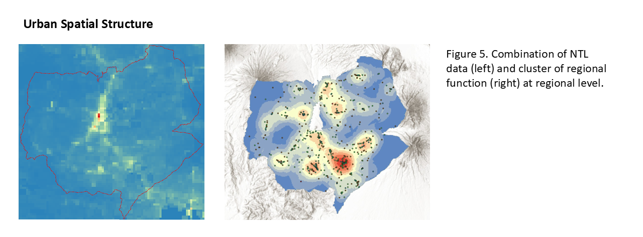
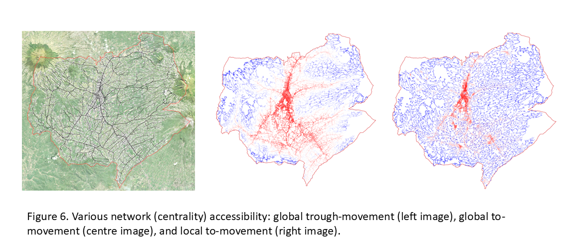
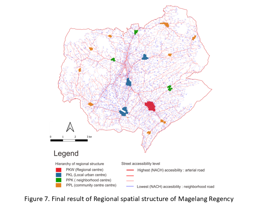
In summary, the results demonstrated that the integrated approach is able to identify urban and regional spatial structure. The network centrality analysis is able to highlight and identify the spatial capital of urban-regional space. Hence, the higher the spatial capital (higher synergy of choice and integration) is typically ideal of higher functional (ie. urban and or regional centre). The assemblage theory is enable to capture the phenomena that neighborhood-urban-regional amenities (Point of Interest) are connected in system and served in hierarchy.
This research contributed to support the following Sustainable Development Goals (SDGs). (11) Sustainable Cities and Communities
(9) Industry, Innovation and Infrastructure
(13) Climate Action
(10) Reduced Inequalities